


2021-02-10_17h59m51_Toscan Bimont Cezanne2

ARPF
User
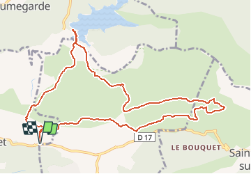

Length
12.5 km

Max alt
455 m

Uphill gradient
486 m
Km-Effort
19 km

Min alt
229 m

Downhill gradient
486 m
Boucle
Yes
Creation date :
2021-02-10 16:59:52.003
Updated on :
2021-02-10 16:59:54.408

FREE GPS app for hiking
 SityTrail
IGN / Geographical institutes
SityTrail Plus
The world is yours!
About
Trail of 12.5 km to be discovered at Provence-Alpes-Côte d'Azur, Bouches-du-Rhône, Le Tholonet. This trail is proposed by ARPF.
Positioning
Country:
France
Region :
Provence-Alpes-Côte d'Azur
Department/Province :
Bouches-du-Rhône
Municipality :
Le Tholonet
Location:
Unknown
Start:(Dec)
Start:(UTM)
704278 ; 4821821 (31T) N.
Comments